Remnantology

Dedicated to the examination of the remnants. Phil Levy's words in reference to history, archaeology, Judaism, academe, music, outdoorsing…

Category Archives: Commemoration

The Road to Mattox and Washington’s Birthplace.

One of the reasons I am so interested in making sense of this landscape is that its residents have centuries of dealing with the relationship between land and water. Of course much of the landscape is hard by creeks and rivers. That might just be a regular fact of life, except that the Potomac has been gaining in force driven by changes to the overall climate and ecosystem. At GeWa this means that archaeological sites like the Henry Brooks site are threatened by coastal erosion. More than threatened really–the site is falling into the river. But managing water here has been a problem for centuries. Large and deep drainage ditches are also one of the most fascinating parts of the landscape and I believe they have quite a bit to tell about where and how people lived on, used, and understood this landscape.

That is a part of why making sense of the maps is so important to me as I try to unpack this landscape.  Here is a problem though that is bothering me. Return to Samuel Lamkin’s 1813 survey and map which are a major touchstone for me. Screen Shot 2019-03-21 at 2.43.17 PM
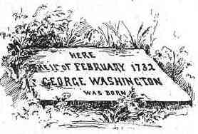
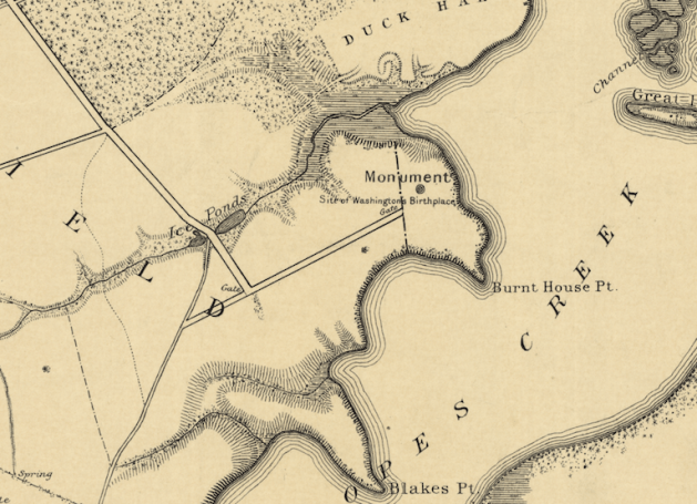
The western border of the Washington land Lamkin surveyed was the road he called the Road to the Burnt House–it is the backwards L I have highlighted in this close up photo. The ultimate destination and name of that road is a question in and of itself, but for now, let’s focus on the spur that breaks off to its south–also highlighted here. Lamkin called this eastbound spur the Road to Washington’s Mill. Indeed, there was a mill at the head of Pope’s Creek for ages–the remains of its 20c iteration are still there to be seen. The area is now called Potomac Mills–not be confused with the giant mall on I-95 near DC. Right where Lamkin has written “Washington’s” there is another road forking with a spur headed back westward–making for a sort of backwards Z of a road.

Screen Shot 2019-03-21 at 2.42.56 PM

Upside down clip of Lamkin’s map showing his Road to Mattox.

It is that last spur–the west heading one–that is troubling me. Lamkin called it Road to Mattox. That would seem to be a reference to Mattox Creek which is the other large creek bounding this land on the west just as Pope’s Creek bounds it to the east. The problem is that it makes no sense to me for the road to Mattox to be here. The Road to the Burnt House seems to end at the head of Bridge’s Creek–the small creek in the middle of the land. The road’s westward turn–the bottom of the backwards L–runs back to King’s Highway which was the main road down the peninsula and more or less survives today as Route 3. That road itself would have run past the head of Mattox, so why then would a road headed there run south of that road when the whole creek is in fact north of King’s Highway. Take a look at the Google Maps screen grab I am posting below and see if you can follow my reasoning. There are a few options. One is that Mattox refers to something other than the creek, but I doubt that. More likely is that this Road to Mattox in fact links back to King’s Highway somewhere close by, but off the map. On Lamkin’s map, both The Road to the Burnt House and The Road to Mattox cut off before we see where they are going–but notice how they both are headed more or less the same direction. It is easy to imagine Kings Highway running up and down just to the left of this map with both roads connecting to it there.

This is the sort of unspooling one has to do when trying to make sense in detail of these sorts of landscapes. One is always working from scraps and no one is going to come in and set you straight. Part of what makes this so important to work out is that local naming practices are valuable clues to how the roads functioned as part of the larger human social network. Every road has at least two directions–two destinations. Thus, the choice to highlight one direction in a name over another says a lot about how the road functioned and how people understood these places. Why is this the Road to Mattox and not the Road to Washington’s Mill–after all it went there as well?  That was a choice. Whose eyes are we seeing through? What does it mean that The Road to the Burnt House seems to be named for something at its eastern end, while the Road to Mattox is named for something at its west? After all, the Road to the Burnt House was also a road to Mattox via King’s Highway–n’est pas? These are choices here and those tell us something about how this place worked. The past people are trying to tell us us something in this subtle way.  Maps kick ass!

Screen Shot 2019-03-21 at 2.58.48 PM.png

Mattox Creek is at the left and Pope’s Creek is right. GeWa is marked with the pin. You can see Potomac Mills at the head of the creek and also note that it sits on Rt 3–the old run of King’s Highway. The section of Lamkin’s map I shared is all happening between GeWa and the place called here Wakefield Corner (a 20c name). That run of Rt 3 between Wakefield Corner and Potomac Mills is what I think Lamkin’s roads are linking to.

George Washington’s Birthplace on C-SPAN.

George Washington’s Birthplace Map and Art.

We need some background. George Washington’s birthplace is in Westmoreland County, Virginia. It is just off of Route 3 about 40 miles east of Fredericksburg. If you drive out to visit there you can also swing by Stratford Hall a few miles farther east and see one of the most remarkable eighteenth-century Virginia homes. Washington’s Birthplace–some times called Pope’s Creek, other times called by its mid-18c name Wakefield–is owned and run by the National Park Service. The site’s NPS name is GeWa (first two letters of a site’s first two names), and I have gotten pretty used to that name. But GeWa is not an easy site to interpret to visitors. There was not much left of the old Washington homestead above ground by the start of nineteenth century. The location of the home—the Washington birth home—that so many have wanted to find has been a mystery since then. Everything built that is visible today is new–and error riddled. For a deeper background on the colonial history of the site and how the park has reported it, take a look at this Cultural Landscape Inventory. It is a good survey of the land ownership history and some of the challenges. It also embeds some of the assumptions we are now challenging.

076birthplace

This is Benson Lossing’s etching of the stone Parke Custis left at the site. Lossing never saw the stone. 

In 1815 George Washington Parke Custis and friends placed a commemorative stone where they thought the home had been, but they relied on the memory of others to locate the site. Since then the focus has been on where that stone had been. Even in the 1920s as the nation was getting ready for the Washington birth bicentennial, debate still focused on a chain of memory used to locate the lost stone. Independent evidence—like archaeology—was made to fit with stories and privileged memories rather receive its just due as an authoritative and independent stream of information. The park is now working to correct the confused mix of stories that have held sway for decades, and I am glad to be helping.

Gewa painting
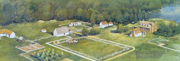
This NPS commissioned painting is a fine representation of the fanciful landscape as imagined by the 1920s folks, here painted with newer understandings of outbuildings layered onto it. It is not a bad vision of an 18c Virginia plantation–it’s just that it is composed of made up parts. No such plantation existed here. The painting shows the fanciful 1920s Memorial House Museum as the Washington home. It was not. In fact, there was very little actual research that went into its building. It was a vanity project by an autonomous group of commemorators and the home looks like a cross between Gunston Hall and Twifford which was the home of the main backer’s grandmother.

twiford-king-george-county-virginia-1024

This is a Historic American Building Survey photo of Twifford in King George County, Virginia. 

Not only that, but they sat their brick version of Twifford atop the remains of a curious outbuilding—remains which were destroyed in the building process. The rest of landscape is more imagination than anything else. We saw the same thing at Ferry Farm where an iconic set of errors were reinscribed with each new rendering giving new life over and over to old error. Nevertheless, this painting captures what visitors to the site see (more or less) and what rangers work so hard to clarify. It is a difficult task since so much of the available information and art is working against their efforts to share a better understanding. The little white outline on the right has been called Building X. That is the set of brick foundation features—excavated in 1930 and 1936 and which we re examined in 2013. These have been labeled the real Washington birth home, but that is a dubious claim at best. The whole site is a work in progress.

Screen Shot 2019-02-24 at 1.39.26 PM

Returning to the 1897 USGC map shows a bit more of this site from a similar angle. What the map labels as “Monument” is the site of the Memorial House Museum. That straight road that runs away from it now extends all the way down to Rt 3. When this map was drafted though, visitors arrived by steam boat on a Potomac dock at the end of the straight road running to the left past the Granary.

Fredericksburg’s Stone in Focus

Screen Shot 2017-08-28 at 12.54.08 AM

If all problems were all easy to solve, there would be no problems. This case is one that presents me with mixed feelings, mostly since I have been considering this for years. The centerpiece here is round block of sandstone at the corner of William and Charles Streets in Fredericksburg, Va. It stands in front of what used to be hotel, but is now a locally owned grocery and apartments. I have lived all over town in my long association with my home away from home, but I have never gotten to live in this building. It sits at the center of a great patch of Civil War era photography—in fact some of the town’s most famous pics were right there in a lot across Charles St. Sadly, no one took a photograph of this corner, and there is very little documentation about the stone as well.

But that does not mean it has no story. It has long been understood as having served as an auction block upon which enslaved Africans were stood so as to be presented to bidders. The warehouse down Charles St is also said to have served as storage area for enslaved Africans before sale. It is all plausible enough—there were enslaved people sold in town, and on this corner in fact. Screen Shot 2017-08-28 at 12.56.18 AMAs NPS historian John Hennessy points out, there is not much else to lock in the story of the block. The local memory though is pretty strong, and needs to be given due weight—indeed, it has. There is a rival story that the block was a stepping stone for carriages and horses, but we can just push that aside since there is nothing about that role that would prevent the block from serving as an auction block as well at another time.

I am not going to take on the question of a thing being a thing. Let’s for the sake of argument say that it is. Or rather, even if it might not be, it certainly has been considered to be genuine long enough and widely enough to have entered the public discussion as what it purports to be (clear…?). What I am interested in though is the memorialization question. Long ago I began asking students, while standing at the stone, to give me reasons to keep it there or to move it. They were always creative and now I wish I had had them write the answers! The one thing that always bothered me though was a curatorial issue. Out in the open air, exposed to the elements, and with cars zipping by, I always felt that the stone was being treated with slight regard.

basement-aug-2013-shenk-215-web

Mountvernon.org

Take the LW stone at Mount Vernon (discussed in chapter six of the book I am writing now! plug plug). It maaaaay be a seventeenth-century survival, or it might not be. In either case, curators wisely moved it into storage and filled it place in the Mount Vernon cellar with a carefully matched and crafted  doppelganger. I have always sort of wanted the same thing done for the Auction Stone—if nothing else just to protect it from a drunk driver.

But now something else has emerged. A group of citizens is asking that the stone be removed from where it seems to have stood (probably stood) since the middle of the nineteenth-century. I first learned of this movement on Facebook and I had a lot of questions. Significantly, the leadership of the group is African American—specifically the contemporary community theoretically most honored by what the Fredericksburg.com editorial rightfully calls an “ugly artifact from an even uglier era in the city’s history.” In this view, the stone is a chastisement and a grim reminder of bad things in an “ugly” past.

slave-block

Fredericksburghistory.wordpress.com

Its presence is an act of atonement of sorts in stone through an ever-present reminder of past sins. But what the people asking for its removal are saying is that, rather, the stone is a needlessly painful reminder of a past that is not so distant from some residents’ contemporary experiences. The people who do not bear the lingering social, financial, and perhaps genetic effects of American Slavery I (1500—1865) and American Slavery II (1865–c1968) might need visible reminders of the past they have the good fortune to be able to otherwise forget. But others may be living more within other more immediate reminders, making some aspects of the past more present for them than for their neighbors. For those people, one stone more or less does not remove, forget, or erase the past. Instead, it might make the present less painful on a daily basis. The editorial suggests an answer—a recontextualization of the stone. The current plaque by the stone is by all measures insufficient. Thus, something richer and more informative is a categorical good. I use the stone each year to spark student conversation, and making the site a more useful teaching tool for everyone appeals to me. But at the same time, moving forward on this will require listening long and carefully to some of the concerns raised by voices within the African American community. It will require walking into those discussions without a “remainer” fait acompli in place. City officials might hear of very real pain which some citizens feel over this, and that that pain is not about a distant abstract past that needs to be remembered, but rather about how that past’s shadow is visited unevenly on people in the present. I have no idea what the memorializing outcome might be, but if that discussion was real and given time to mature, it would be a huge step forward in and of itself. It could be the stone upon which a new consensus could be built.


Barbados, Day Two

Today began very gray but cleared up. I got up early and rushed back to town to try to recover my glasses which I had left on a wall in the cemetery. The Shul was open when I got there, so I had the pleasure of saying shacharit (albeit alone) in the beautiful old Nidhai Israel shul. It is very much like a British shul with the same type of stying and pillars holding up the women’s gallery. One difference was that the Bimah (raised reader’s table) was in the back and not in the center. I am a big fan of facing bench seating in shuls–in my mind it plays down hierarchy in favor of communalism.

IMG_2746

The Bimah in Nidhi Israel

This building dates to about 1831 when the great hurricane demolished much of older Barbados. This new shul sits on the foundations of the original which dated to the mid seventeenth century.

Some visitors came through and they must have thought that I was some sort of museum display set up for effect and authenticity. When I was done, Emerson, the tender, directed me to meet Benny Gilbert, a retired local property developer and one of the community’s elders. His wife is an Altman—one of the oldest Ashkenazi families on the island. Mr. Gilbert invited me back to his office for coffee and a chat and so we walked though the crowded Bridgetown streets having the kind of conversation one would have any where in the world after saying “shalom alechem – alechem shalom.” Mr. Gilbert had much to share about the island, its Jews, and his life as one of them. He explained that the original Spanish community was all but gone by the end of the 18c and that the Ashkenazim came in waves, many spending a few generations here and then fading away only to be replaced by new families. This was much the same as I had seen in some places in England—wandering, to paraphrase perhaps the most famous (sort of I guess) English Jew, Shylock, is the badge of all of our tribe.

IMG_2761.JPG

The shul is on the left, and the mikveh newly built is on the right.

I returned to the Shul after my visit and got there in time to see that the guide had brought visitors in to see the mikveh. This 1650s bath was discovered archeologically a few years ago and once the stone rubble had been removed, the water returned. It requires no filtering—it is fresh, clear, and tapped into the water table.

IMG_2758

Newly rediscovered mikveh

They have built a very lovely building over it from the removed stone rubble and it is quite a gem. I waited and listened to the talk about how the 17c Jews here used the mikveh—a description based largely on 17c travel narratives. The mikveh is not formally open to the public (vistors can look in with the guide), but religious exceptions are made from time to time. A few weeks ago a pair visiting Chabniks went in and today it was my turn. The water was clear and cool and the stones 17c. It was a remarkable experience.

When I was done I went back to looking over the grave stones to find specific people I was curious about. In looking around, there seems to have been some surface level change though. Some nearby construction has left some holes and poked around a bit just outside the footers of the old cemetery wall.

IMG_2764.JPG

Construction and stones.

I saw at least four layers including two that appeared to be mostly pavers. The most interesting thing was that this new construction had uncovered a section of the cemetery that had been buried and had had 19c shops atop it. Those shops have been gutted and their floors removed. The result are the most amazingly well-preserved stones in the yard.

IMG_2767.JPG

Newly exposed stones. The doorways on the right are at current surface level and lead out to the street.

These are mostly of English Jews, some of whom had adopted the stone styles of their Sephardic predecessors. I am told that the development plan calls for all the graves to be reincorporated into the cemetery which will retake its original size. More on the stones later.

Much of the rest of the day was spent at the George Washington house again, this time looking over the artifacts from the 1999 and 2001 excavations. I have the reports and the artifact lists in them, but the only way serendipity can happen is when you let it. The excavations were primarily in the ravine west of the home. The collections span a large period and of course trying to find 1751 in an assemblage is not an easy task.

Once I was done, I thought it would be nice to get out into the countryside.

IMG_2914.JPG

Looking south from the first major rise of land.

I was right. I drove north mostly by zigzagging the road system. The south has a large sloping plain, so that heading north means heading up as well. As Washington observed, the landscape is made so that views of the sea are to be found throughout.

IMG_2917.JPG

Drax Hall. In private hands and not open to the public, but still owned by the Drax Family in England as it was in the 17c and still producing sugar.


I wended my way up to Drax Hall—a well known 17c plantation and home just about one third up the island from the south coast. Sugar is still grown here in the hundreds of tons for shipment to European markets. Interestingly though, none of the Bajan plantations produce any molasses. That means that all the Barbados rum is made from imported molasses—not local. There is a metaphor for something in there.


Fredericksburg’s Farmers’ Bank: History vs the Tarmac Desert.

In the summer of 1862 President Lincoln visited the city of Fredericksburg. 
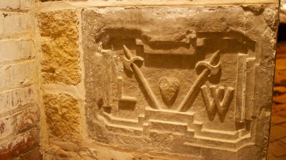
Soldiers of the United States had recently captured this hub of rail, road, and river virtually without incident and the President was in town to meet with his theatre commanders and to see the prize. Halfway between Washington and the Confederate capital of Richmond, Fredericksburg’s capture was one of the last moments when rational people could imagine that the war would be short and relatively painless.
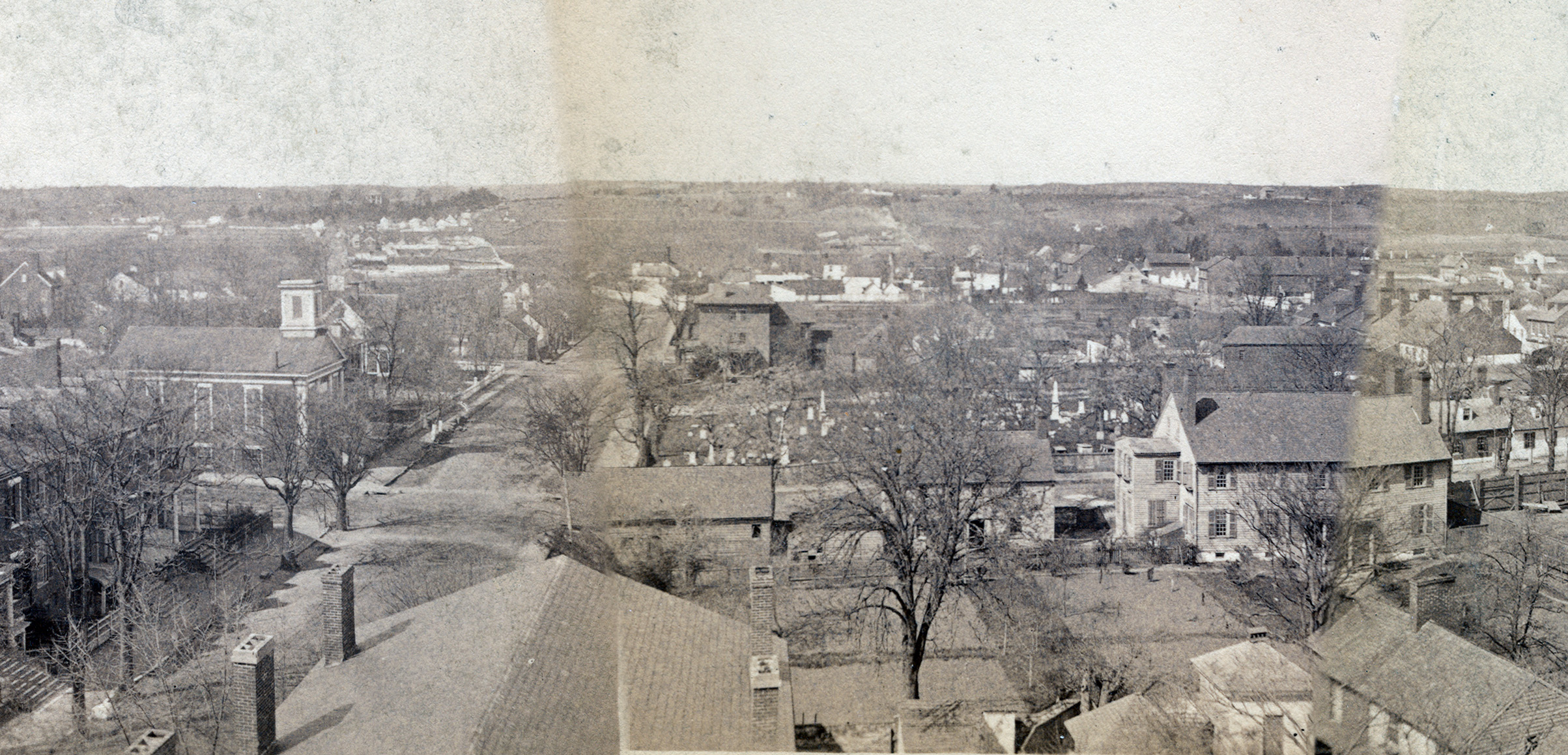
Lincoln held meetings and visited local sites—including George Washington’s childhood home. In town, he met with General Marsena Patrick in the two-story neo-classically inflected Federal style Farmers’ Bank. The bank sat on the corner of Princess Anne and George Streets right across from St George’s Episcopal Church on its front and the town’s Presbyterian Church on its eastern side.

This section of the much-discussed 1888 St George Church panorama of Fredericksburg shows the roof and chimneys of the Farmers' Bank on the left foreground. Note the use of the lots that are now mostly tarmac deserts. This section of the panorama came from Fredericksburg Remembered. http://cdn.loc.gov/service/pnp/cph/3c00000/3c00000/3c00600/3c00623v.jpg

This section of the much-discussed 1888 St George Church panorama of Fredericksburg shows the roof and chimneys of the Farmers’ Bank on the left foreground. Note the use of the lots that are now mostly tarmac deserts. This section of the panorama came from Fredericksburg Remembered. http://cdn.loc.gov/service/pnp/cph/3c00000/3c00000/3c00600/3c00623v.jpg

Though lacking the adornments of ecclesiastical architecture, the Farmers’ Bank’s facade, style, and placement was nevertheless itself a statement of faith, solidity, and the American way. General Patrick’s selection of the bank as his own office—and a nerve center of the city’s occupation—enlisted the existing architecture of trust, power, and commerce for the for the cause of the Union.

The Farmers’ Bank has survived to today.

The Farmers’ Bank as it looks today. Image from Mysteries and Conundrums https://npsfrsp.wordpress.com/2011/01/17/slaves-at-fall-hill-abraham-and-hester-tuckson/

It has been a bank and office suites most of this time and is now one of Fredericksburg’s best historical buildings. Indeed, Fredericksburg NPS Battlefield Park Historian John Hennessy recently highlighted this fact for his blog readers reminding all that the bank is the only existing building we are certain Lincoln entered, walking over the bank’s worn Aquia sandstone steps and entering through the elaborate alcove entrance. The bank’s northeastern corner is especially notable for the large amount of Civil War graffiti resulting from bored soldiers carving their names and regiments into the brick (Other Civil War graffiti). In the 1930s, Historic American Building Survey architects studied the bank (then called the National Bank) and added it the list of the town’s charms. A 1990s drive through window and cash machine addition south of the bank are the only externally visible changes to the building which otherwise has maintained its historical feel capped off by a wooden Civil War era style sign.

But changes in the larger lot have left the Farmers’ Bank an isolated historical Island in a tarmac desert. Beginning at least as early as the 1950s, Fredericksburgers transformed open in-town spaces into parking lots.

Seen in order on the right, the 1990s drive through bank addition, the south wall of the Farmers' Bank, and the steeple of St George Episcopal Church.

Seen in order on the right, the 1990s drive through bank addition, the south wall of the Farmers’ Bank, and the steeple of St George Episcopal Church.

In the nineteenth century, open lots were needed as work yards, kitchen gardens, and animal residences. But in the automobile era—and particularly after the 1960s when I-95 passed just west of town—the storage of temporarily dis-used cars became a primary concern. Property owners paved open lots and, as older buildings came down, their empty lots also joined the ranks of parking lots often in the shadow of roughly constructed side walls of remaining buildings meant to be seen only from the front. The result of this was to leave town feeling cold and gap toothed and filled with unplanned areas of undesirable, mostly unused, open spaces.

A Tarmac Desert on Sophia Street.

A Tarmac Desert on Sophia Street.

Once a lot is paved, the city or the owner are now committed to a never-ending maintenance regime as cracks have to be filled and holes patched. Paved lots also force collected rainwater to funnel into streets thus stressing removal systems, increasing flooding, and accelerating the erosion of older cobbles. The answer to this is of course more paving, so that over time, more and more of the cityscape became a tarmac desert. Whereas earthen lots absorb rainwater and produce greenery even when left alone and require no maintenance other than occasional mowing (or goat keeping), tarmac deserts produce nothing other than that distinctive smell in the heat and make corners for the collection of wind-borne trash. On top of that, the in and out flow of cars provide visible markers of when people are in a building and when they are not. The absence of cars signals a building’s emptiness to burglars while a dark lake of tar is itself an inviting terrain for all sorts of mischief. Nothing feels emptier than an vacant parking lot—and in Fredericksburg, most parking lots are empty most of the time and, being paved, can do nothing other than wait for the next car to park there. Paving a cityscape makes it an uninviting alienating tarmac desert that seems dark and dangerous most of the time.

The Farmers’ Bank sits now at the corner of just such an in-town desert. That makes the bank feel isolated and even irrelevant. This is just one of many ways whereby reliance on automobiles and that dependency has remade the landscape in ways that challenge preservation and a place’s historical feel.

The west wall of the Farmers' Bank with the drive through on the right. Note the sale sign.

The west wall of the Farmers’ Bank with the drive through on the right. Note the sale sign.

But now the bank faces a new threat—one worse perhaps than the shells and pocket knives it endured during the Civil War. When the economy bottomed out in 2008 most of Fredericksburg’s development project ground to a halt New condos near the rail tracks which once boasted signs claiming “Starting at $400,000!” soon boasted starting prices of $150,000 before being cut up into apartments. Subdivisions simply stopped with streets half fleshed out and stripped fields were left alone to regrow what grasses they could. Businesses failed and storefronts replaced displays with For Rent signs and papered-over windows. But all of that is over, and the development economy is once again booming. In a very short period of time the city saw a massive new courthouse constructed, a new downtown hotel right across the street, and many new homes fitting in between older ones. In just this last year new in-town projects have piled high-end housing into town and added eateries and even a glittering south-western styled brew pub.

Postmodern newly built townhouse filling in open spaces on the left and the stunningly out of place brew pub sitting on the corner of William and Winchester streets.

Postmodern newly built townhouse filling in open spaces on the left and the stunningly out of place brew pub sitting on the corner of William and Winchester streets.

The good news (perhaps) is that much of this new development is taking place in lots that were previously tarred over. That addresses some of the aesthetical problems posed by tarmac deserts, but none of the environmental or historical preservation ones. The bad news is that all of this is happening so quickly that thorough archaeological is very challenging—and it seems in many cases that significant finds would not be enough to slow down the pace of building or even redirect it. Speed also leaves preservation–of buildings as well as less tangible but nevertheless important things like view sheds and historical feel– left in the dust and crushed by the bulldozer’s treads. Right now the future of the Farmers’ Bank is in question. A developer had bought the lot and received initial approval to fill the desert with condos. But the plan bogged down in levels of city government and all is on hold for now.

New construction on William Street right next to 19th century rows

New construction on William Street right next to 19th century rows

At this year’s Council for North Eastern Historical Archeology conference in Fredericksburg, there was discussion about how the city, still lacking a protective archaeological ordinance, may be turning a blind eye to the destruction of the town’s material patrimony–a patrimony daily stewarded by Fredericksburg, but in reality owned by the nation. Again, the good news is that the city is on the way to hiring a preservation specialist to monitor work. Again, the bad news is that no one knows just how influential that person will be once hired and how much we may lose in the meantime.

Meanwhile though, decades’ old bad car-driven choices are still felt in a town walking the line between protecting its past and building for its future.

Recalling the Jews of Falmouth

Early on Erev Yom Kippur, aided by sections of Keith Pearce’s and Helen Fry’s book The Lost Jews of Cornwall I took a break to explore the Old Jewish Cemetery in Falmouth, Cornwall. The University of Southampton’s  Mark Levene clued me into the fact that it happens to be right on my walk between Penryn and Falmouth across the road from the Sainsbury’s. The eternal and the fleeting cheek by jowl.

I pushed through the overgrowth and crested collapsing stonewalls to find the three-dozen some odd headstones that make up the remains of what was once a strong but small Jewish community. As that celebrated English drizzle fell, I sang Tehilim (psalms) for my bothers and sisters there interred and wished an elevation for each and every one of their souls.

Stones in the Falmouth Jewish Cemetery on the A39.

Stones in the Falmouth Jewish Cemetery on the A39.

The stones were mossy and many were toppled and broken, but many were still readable (but Pearce’s and Fry’s work was there to fill in the gaps). Some inscriptions were quite plain providing little more than a name and a wish for external life. Some hinted at family tragedies like the fact that Yissachar ben Yoel HaLevi and his son Levi both passed away in 1791. What a loss for the family as well as for this then quite small band of Jews. An undated stone marked the grave of Yoseph, infant son of Lyon Yoseph and his wife Yehudit. Moshe ben Yisrael who died in 1798 was recalled only as being an unmarried man— the first time Moshe wore a tallit was to be buried. How are we to understand that subtle but nevertheless heavily freighted lament from within a community that had to cling tightly together to survive?

Many of the stones hinted at the process of adaptation that Jews have undergone wherever we have settled. Names—some written in English and some in Hebrew—revealed the workings of that familiar process whereby we have our real names—the ones that function within the community, the names called out in synagogue, first ours and then our father’s (“ben” meaning “son of”) when we are honored or when we are ill and the congregation negotiates with God to heal us (and, as the wonderfully contractual prayer also says “and for all Israel as well, amen”), the names we are given soon after our births and the names that in the end, the stone carver will chisel on our tombstones. This naming game is a brilliant one—intended or not. Their simple familiarity erases time. There is no fashion in these names—nothing to make people seem quaint or antique, nothing to make them seem at all of a different time. No Pheobes or Alonzos, no Winifreds, Theodores, or Gouevenors to make one think, “hmm, don’t see that name much anymore.” Likewise, there are no Ambers, Tiffanys, or Tylers to seem so of the moment. Instead, we use the same names over and over so that people, dead these two centuries, bear names no different that those around us now.

Jacob Jacob of Falmouth painted around the time Darwin was in town.

Jacob Jacob of Falmouth painted around the time Darwin was in town.

Yitzhak ben Yoseph (a reversal of my own father’s name), Yishaya ben Moshe, Uri ben Zvi, Yakov Eliahu ben Naftali, Yehuda ben Yehoshua and so on—nothing in these names hints at epoch—they are no different than we hear week after week in synagogues all over the Jewish world. Time and space vanish thanks to a simple paring of a son’s and a father’s name.

But Jews have long lived amidst people with whom we did not share our real names, or frequently people whose naming styles we took up and made real in a new way. The Falmouth stones show us this process at work. Yissachar Behr ben Yoel haLevi conducted his daily affairs in Falmouth as Barnett Levy while Yakov ben Moshe was known to his English neighbors of the early nineteenth century as Jacob Jacob of Falmouth.

The stones also hinted at ethnic and gender differences as well. Whereas the men mostly had biblical names, many of their wives were recalled with altogether less formal Yiddish names. Yetle, Feigele, Gitteleh, and Beila show unmistakable family roots on the continent. But at the same time, names like Saavil on one stone and the de Pass family from South Africa (a Sephardic family noted by Pearce and Fry) show diversity even in this singularly Ashkenazi community.

A few days later I found the old synagogue the community built about 1800 and which Britain’s Chief Rabbi ordered sold off once the community had faded away in 1888. It was a simple but distinctively German style shul with red brick and local stone coynes along the front corners. Its tall windows offer just enough of a glimpse inside to make one wonder what else survives therein.

The Old Falmouth Synangogue, 1808 - 1888.

The Old Falmouth Synangogue, 1808 – 1888.

The shul has a commanding view of the harbor below. It sits at the top of a street called Fish Strand Hill. At the base of this hill there is a plaque that says that Charles Darwin boarded an overland stagecoach at this spot on Sunday October 2nd, 1836 after the Beagle had laid anchor in the harbor. That day was also the 21st of Tishrae 5597—Hoshanah Rabbah (tomorrow), in the last days of Sukkot. At that time Falmouth’s Jewish community was in full flower and would have been in shul carrying lulavim and parading around the bimah. I consider this because I am here writing this during the same week in Tishrae passing Sukkot in Falmouth amid the ghosts of a lost community and their still living names.

“Ask A Slave” and Unintended Meanings

http://www.gofundme.com/AskASlave

http://www.gofundme.com/AskASlave

These videos have been making the rounds and I wanted to comment on this all. Yes, they are clever — even very clever. Yes, Dungey is talented and this is an imaginative way to promote herself as an actress and hit some social consciousness bells along the way. I respect her and her project and look forward to seeing how students react. But at the same time, it made me squirm on so many levels and raised some red flags.

The Stupid-Visitor-Question-Story genre is a staple of museum culture– and as Handler and Gable amongst others have pointed out, that is not always a good thing for either visitors or museum staff. Interpreter-visitor encounters are usually imagined as being a charming educational moment. But often these are in realty tense tug-o-wars with smugness on both sides and a high degree of trying to embarrass as well. At least visitors have the option to ask intentionally stupid questions to make their friends laugh–I suspect that that is in fact what is behind many if not most of these stories–visitors intentionally screwing around with staff. In that way, visitors get a double bang: make friends laugh in the moment and have the more incredulous repeat the feat over and over. Hey presto, a manner of immortality.

On the other hand, for interpreters, encounters are full of risk. Staff may suspect that they are being screwed with, but face employer retaliation if they get too snarky. Interpreters have to treat every question as real and have to be engaging in responding – their continued employment depends on it. Thus, the Stupid-Visitor-Question-Story genre becomes a sort of spiritual haven for people who are paid poorly, work their asses off in often harsh conditions (being in a blacksmith shop or a recreated eighteenth-century kitchen all day sucks now as it did then) and also will never be granted much intellectual respect or credibility from academe. These folks often see themselves (rightly or wrongly) as permanent second-class citizens in historyland. Most lack the kinds of schooling and publishing records academe cherishes, but do have often very detailed fine- grained knowledge of their fields. On top of that, they often have an intuitive knowledge that comes from experience—-something that is immensely valuable to museums and visitors, but always just a bit suspect to “book learning” historians. Buy an experienced interpreter a drink and they will tell you how irritating visitors are. But buy them a second drink and they will tell you what arrogant exclusive jerks historians can be.

What worries me about these film clips is the stupid visitor story being too public a performance. I see it as only encouraging visitors to play at this even more. But worse still, I worry for how museums (read employers) will see this. They are famous for retaliation and are always deeply concerned about public image. I don’t imagine that Mount Vernon is at all happy about this sort of “unmasking” and I wonder what HR policies may ensue not just there, but elsewhere as well. It is fun to laugh—and Dungey is good at making us do that. But, museums are workplaces and interpreters are staff, often very vulnerable staff at that. These clips viewed that way are so very full of issues of domination and resistance. The very title “Ask a Slave” is far more meaningful than most gleeful watchers might know.

Reenactor Divisions

Tony Horowitz made famous a certain divide within the Civil War reenactor community–the dived between so called ‘hard cores’ and the rest. In reality though divides were always more complicated and nuanced. This essay from Jesse Marx on Salon.com highlights the divides made more pronounced by the rise and decline in popularity of the hobby–the same sort of issue I wrote about a few posts ago. I was with this group for one event many many years ago, although the membership has no doubt changed three times over. Particularistic units like this face a unique problem that marginalizes them from some reenactor visions. Uniquely uniformed groups help make an embarrassing patchwork that emphasizes the eccentric in place of the common. An event will never have more than a handful of these uniquely uniformed men, and that can never look like a company or regiment as they would have been in the field. So instead you get a surrealistic mix that undermines the attempt at uniformity (within limits) one would have seen on the field. People are attracted to these singular uniforms, but often for simple peacocking reasons and nothing more. Men wearing their best ordinary issued uniforms have a flexible generic quality that better represents what the armies in the field looked like.

Crpl Ignatz Gresser: Hard Core model and man of style.

For that reason, so-called ‘hard cores’ long ago adopted a “commonest is best’ approach for most events while sewing specialized kits for rare appearances. Back in my day (the beginning of the ‘hard core’ movement), we used to invoke one man–a Pennsylvanian named Ignatz Gresser–as the model to look to. Apart from his obvious force of character, Gresser was as ordinary as a man could be. Everything he had was plain issue–probably mostly Schuylkill Arsenal–and he is clean and tidy, not shaggy and silly. It was the habit of many Pennsylvania non-commisioned officers to adopt the dress frock coat since regulations allowed only for stripes on these coats, and not on flannel fatigue “sack” coats. No “baseball”  rounded brim, Gresser shows ideal hat posture for a cap made as they were then (and usually not now) and notice the hardtack flare. He is simply dreamy!

The advantage of this approach is flexibility and good representation. A patchwork army of every colorful oddity that may (or may not) have one time appeared on a battlefield was always something we derided. Nevertheless, even through the 14th Brooklyn is an odd place to land for Marx’s discussion, his is a very good one.

Painting Perspective / Teaching Paintings

Travels happened me by two major Civil War sites this summer. Of course I had visited both Gettysburg and Antietam many times before, but I thought that the detours were well worth the extra miles and gas so that I could see these places in the midst of the 150th celebration. I am working up a week’s readings on the 150th for my seminar this fall and was also fishing for assignable tidbits. I wanted to see both of these sites because of the special role they have played in Civil War landscape memory. Both are gems—beautifully maintained acres, shaped vistas, and of course amazing collections of monuments. Proximity to Northern railheads made these places the most commemorated battle sites and that century-old legacy has made Gettysburg, at least, a massive tourist site.

Both sites have well placed museums that work well with the site’s story and the flow of visitation.

Antietam on a perhaps digitally enhanced beautiful day.

Antietam’s museum is the older of the two, although it is very proud of its new introductory film—a reenactor-heavy narrative of the campaign peppered with talking heads like James McPherson. Gettysburg has a newly-built state of the art visitor center reflecting current museum trends and is a magnificent shrine to all things Civil War. Its equally new film, though, is a Gilder Lehrman Center product, and as a consequence is very current and comfortable with the political context of the battle and the war—something usually less evident in this genre. Visitors receive a sophisticated lesson in the politics of slavery and the war itself.

Both museums, much to their credit, devoted space to discussing landscape memory and the creation of these places as battlefield parks. Unsurprisingly, though, most visitors passed through these areas somewhat quickly—perhaps too quickly. But in both museums what caught my eye was a lamentable example of Civil War myopia—that familiar inability of some enthusiasts to imagine a past outside of 1861 (or maybe 1859), to 1865. In this case, it was connected to paintings both museums display.

Both Gettysburg and Antietam display breathtaking works of nineteenth-century art even though neither treats them as the masterpieces they manifestly are. These are paintings of battles scenes, Gettysburg’s is the work of a master and his crew, while Antietam’s are more vernacular in approach. Both sets of canvases are well known—so I am making no claim to a discovery here.

A small section of the Cyclorama.

The Gettysburg “Cyclorama” was the core of its own much-visited auditorium long before it was incorporated into the new NPS visitors’ center. The five Antietam battle scenes may be a bit more obscure, but they were included in Time Life’s much-read Civil War series, giving them a wide audience. My point, or rather what struck me on seeing them on this visit, was not their well known existence, but rather, the way their “artness” is all but ignored—subordinated—to the battle narrative at the center of the museums’ battle stories.

In both cases there is good and compelling reason to talk about these paintings as art, and not just as simple imaginary windows into the battle as they are currently viewed. At Gettysburg, visitors see an admirable Gilder Lehrman film and then walk upstairs to have a guide use lights and recordings to awaken the climactic moment of Pickett’s Charge on the third day of the battle. The vehicle for that experience is a vast painting (or set of paintings, really) that make up a huge 360 degree panorama augmented by wonderfully evocative landscaping that begins where the canvas ends at the floor. As lights come on and off , recorded explosions and dramatic “glinting bayonets” language create a “you are there” feel, and people love it. But what they are loving is a late nineteenth-century form of popular entertainment. Indeed, there were several of these immersive environments that patrons could see from Coney Island to the various expositions as well as all over Western Europe. This is the same art form that one can still enjoy in a more “naturalistic” setting in cases at the Smithsonian Museum of Natural history or at New York’s version, to name just two. Realistic, grand, and employing a brilliant level of craftsmanship, what makes the Gettysburg Cyclorama so gripping is all—all—the brushwork of master craftsmen.

In this case the artist was Frenchman Paul Philippoteaux and a team of selected workmen.

Philippoteaux at work

Nearly 20 years after the battle, he studied the area, commissioned detailed photographs, and spoke with survivors and then set in to create a true masterwork. But despite his research, the painting is oddly French. The soldiers wear uniforms that are clearly French in cut and markings–well beyond the French influence common in American uniforms of the time–and much of the equipment is French in form as well. The main house in the image is not made of the stone it was in real life, but is instead plastered brick in a French style, and most tellingly, large conical French haystacks dot the Pennsylvania fields. The result is an American moment filtered through French artistic eyes—one wonders if what we are seeing is Gettysburg, or some sort of Franco-Prussian War parable. These are wonderful jumping-off points for discussion. Yet, during our visit, the guide never even mentioned Philippoteaux (even though the paintings’ first showings boasted the painter’s name as loudly as the word “Gettysburg”).

The old Cyclorama

Visitors’ questions afterwards focused only on “who was where,” and no one felt any need to inquire about the art they were loving so—and no official papers or voices on hand even suggested that they might want to. Julia King has written about how museums’ uses of seventeenth-century Dutch paintings to describe uses of found artifacts work to superimpose antique discussions of class and gentility, and naturalize the effects of those hundreds-of-years-old texts.[1] We see the same thing here. These paintings were meant to teach, commemorate, and entertain—with an emphasis on the latter two, especially considering that still-living veterans were a major visitor constituency. Indeed, the paintings still serve these goals, except in that now the notion of teaching seems to have outstripped the other two missions—this art is a surrogate vantage point, a means of time travel, and an unquestioned authority for visitors. All of this grants a unique validity to a very singular artistic vision while rendering invisible the artist(s) and the process and logic of the paintings’ creation. That is a shame really.

A similar thing happens at Antietam. There, five huge battle scene canvases portray crucial moments of that messy and poorly executed fight.

James Hope’s painting entitled “Artillery Hell.”

The paintings were the work of James Hope—a painter and Union veteran who painted these remarkable canvases in his Watkins Glen, New York workshop around 1892. In time the paintings ended up in a church and in 1979 became NPS property. The NPS does a good job of telling a small version of their story online, and the exhibit gives a wonderful description of the effort to save one of the damaged canvases. But, there is almost no effort in the display to talk about Hope, how and why he made these masterpieces, or even the larger context of survivor art. Again, the result is that the paintings are simply teaching aids—a role that misses an huge opportunity and sells these works short.

Both settings have the physical space to discuss these paintings as art. I suppose what is missing is the interpretive space. I hope that  can change and that visitors can see this moving remarkable art as art.


[1] Julia King, “Still Life with Tobacco,” Historical Archaeology 41:1 (2007), 6-22.

%d bloggers like this: