I have been considering this for some time. Alena Pirok and I have discussed this for ages and this last fall she had her Armstrong State undergrads explore the remnantology concept. They posted their images on Instagram and it was a real treat to see them play with the idea. But what is the idea? Obviously, I think enough of it to have named my blog after it. But I have yet to fully put into words just what I mean by it. It was one of my only attempts to coin, or re-coin a term. The word itself comes from a subfield of botany and biology, but I see huge material resonances in it. I am working on the chapter ideas for the book on this, but for my own clarity, and for others’ as well, I have sketched out the start of a Remnantology Manifesto that begins to put in words what I can see in the periphery.
The Remnantology Manifesto
Human beings have been busy changing this planet to suit their needs ever since the two  first met. Those who know, inform us that the human species’ ability to manipulate its environment to suit its specific needs is the principal evolutionary advantage these animals have had over others. This has meant that human history has been filled with the making and remaking and remaking yet again of the places humans have called home. This endless game of revision and modification has left the world littered with remnants—each change large or small displaces something that was there first. In some areas, the change can be dramatic—say for example a farm field transformed into a subdivision. Other times though change can be as light as simple reordering, a shifting around of elements, a layering of one way of using a space atop another. Uses, ornaments, components, can be swallowed up by remaking, renovation, and host of other intentional changes. But there is a separate class of artifacts that just stay where there are unchanged, un-reused, and overlooked. These bits are not in the way enough to cause trouble to how things are being reordered, nor do they need to change to be part of something new. They no longer matter—and at the same time, they are in no one’s way so they illicit no fuss or concern to remove or change them. These objects are Remnantology.
Principle One: Remnantology is a species of Stratigraphy.
In archaeology, the concept of stratigraphy rules the roost. This is the idea that layers form over time and in the perfect conditions, as you move down through the layers, you move “back in time.” The fundamental principal of excavation is the removal of layers (as well as other fills and features) in an orderly fashion to record each and in so doing go deeper in space and deeper in time. Not so with Remnantology—it can be observed, but it cannot be removed to reveal more. It just exists. Yet, Remnantology shares stratigraphy’s understanding of accretion, but the implied horizontality is not there. Remnantology has no layers, but it has superimposition.
 Principle Two: Remnantology is Material.
It must exist. It must be a thing—you can touch it, break it, throw things at it. It can be painted, crushed, or stepped on. It must be observable. Remnantology is composed of the things left behind, things that once were vital to how life worked, but have been left behind in some version of their useful state.
Principle Three: Remnantology Hides in Plain Sight.
We are all surrounded by Remnantology—it is fundamental to how the material world is ordered. The challenge is to re-orient how we see what we see, and what we understand of what we see. In that way, Remnantology is way of seeing the world.
Principle Four: Repurposing is not Remnantology.
Repurposing is an act of intentionality. To take a thing, tidy it up, and find a new use for it is really to reintegrate it back into how life is lived. This is fine—valuable even. But it is not Remnantology.
Principle Five: Hate is not the Opposite of Love—indifference is. Remnantology resides in Indifference.
Being overlooked is crucial to being Remnantology. Hatred leads to removal and demolition. Love leads to fetishizing and repurposing. Remnantology is in the middle. Forgotten.
 Principle Six: Abandonment is not Remnantology.
Many Remnantology objects seem to be abandoned—and indeed many are left behind. But abandonment is a category unto itself. Garbage is abandoned, a burned out car is abandoned, a home can be abandoned. None of these though are Remnantology. Like Remnantology, abandonment entails a thing no longer being needed for its intended purpose. But, something abandoned is in some way hindering something else’s function. Garbage will eventually be cleaned up. The burned out car is blocking a street or a parking space and is itself a species of nuisance. The abandoned home is in a transitional state—on its way towards demolition or rediscovery—and in the meanwhile is stopping something else from occurring. Remnantology on the other hand, impedes nothing, interferes with no vital action or activity, and not in a transitional state. It just exists.
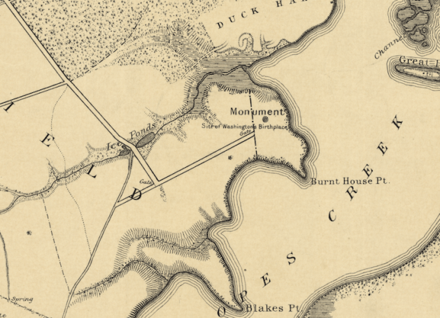
 The western border of the Washington land Lamkin surveyed was the road he called the Road to the Burnt House–it is the backwards L I have highlighted in this close up photo. The ultimate destination and name of that road is a question in and of itself, but for now, let’s focus on the spur that breaks off to its south–also highlighted here. Lamkin called this eastbound spur the Road to Washington’s Mill. Indeed, there was a mill at the head of Pope’s Creek for ages–the remains of its 20c iteration are still there to be seen. The area is now called Potomac Mills–not be confused with the giant mall on I-95 near DC. Right where Lamkin has written “Washington’s” there is another road forking with a spur headed back westward–making for a sort of backwards Z of a road.


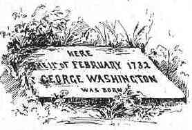
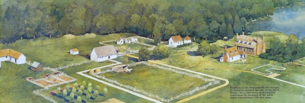 This NPS commissioned painting is a fine representation of the fanciful landscape as imagined by the 1920s folks, here painted with newer understandings of outbuildings layered onto it. It is not a bad vision of an 18c Virginia plantation–it’s just that it is composed of made up parts. No such plantation existed here. The painting shows the fanciful 1920s Memorial House Museum as the Washington home. It was not. In fact, there was very little actual research that went into its building. It was a vanity project by an autonomous group of commemorators and the home looks like a cross between Gunston Hall and Twifford which was the home of the main backer’s grandmother.


Recent Comments