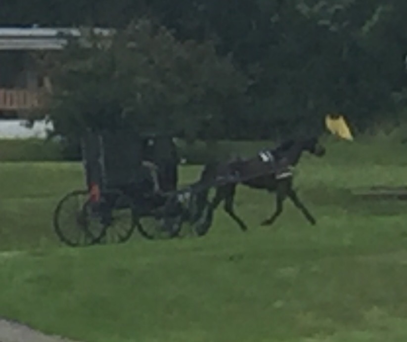
Riding the C&O Canal Towpath.
I had forgotten–Maryland is this reason people don’t go camping. Think of it: make a little list in your mind of all the reasons you, or others of your acquaintance, spurn the out-of-doors. Incessant heat, clouds of mosquitos and black flies, air so humid that nothing ever dries, mud, rain–all of these probably top the list. Well, I am hiding in my tent at 8pm so as to get the bugs out of my ears and skin. It is not so bad while riding, but once you stop, they assault you. I got the tent up I am skipping cooking dinner so I can just hide in here. I did manage to do my comedy routine at the muddy river bank though. Clothes off, slipping, landing on my naked butt, getting up, slipping again–all quite dignified and of course just as I planned it.  I got the collected trail dirt off me, but the slip and slide allowed me to collect some new mud. I went up–buck naked–to the water pump to clean up. Of course I had the campsite to myself, so my aggregious lapse of modesty was not seen–at least as far as I know. But just in case a small team of bird watchers were subjected to a rude surprise, or some stealth campers had their view ruined, all I can say is, I hope you enjoyed the tan lines.
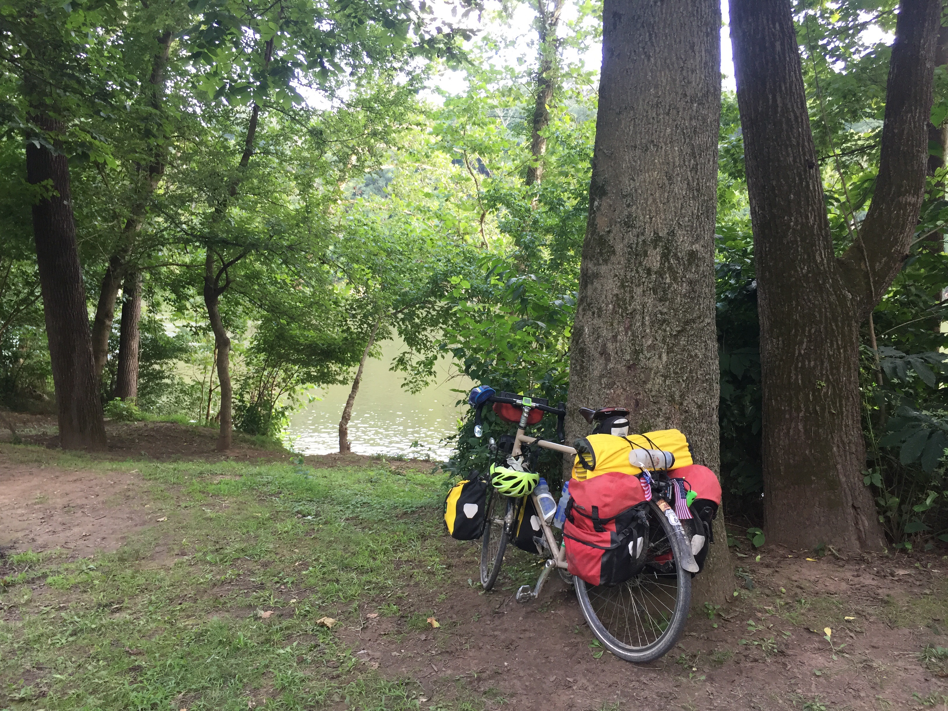
The Canal side campsites all have water pumps–the old style ones that require some vigorous pumping on the long handle before the water flows. These are wonderful, the water is fine (iodine does not bother me) and they are a boon. But they are annoying to work solo. You see, many humans come equipped with only the two arms. That means that if one arm is busy pumping, that leaves only one to take on other tasks. If the goal is only to fill a water bottle, then that is not too bad. But anything more complicated, such as washing a muddy set of riding shorts or cleaning mud from a naked backside can be rather more tricky. Operating the pump gets even trickier if you add to that the need to keep an eye up and down the trail lest a group of nuns come walking down the path or a string of Japanese tourists on all-terrain Segues whizzes past. These are purely hypothetical situations of course, but I share them here just in case the Park Service is considering a new water distribution system that more fully enables the cleansing of objects, appendages, and various fissures.
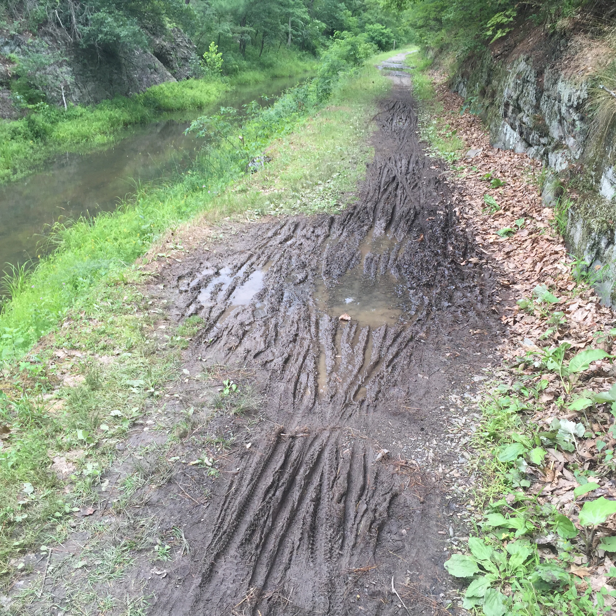
The towpath is its own special challenge. Whereas the Great Alleghaney Passage (GAP) and the Katy are packed crushed stone, and the various Ohio trails and the Motour are mostly paved, the C&O is nothing of the kind. It is made up mostly of mud, sticks, and bits of dead mules. At intervals, when a pot hole gets particularly deep or one of mules finds its way off, the park service brings in gravel to fill the void. Other sections have packed sand while still others are almost entirely fairly loose gravel. The whole 180 mile long track is prone to deep sticky potholes when wet. All of this means that the run is a constantly changing array of unpleasant surfaces. The rain I hid from in Ohio fell in Maryland and collected in nice deep puddle trap all the way from Cumberland, Maryland to DC.
The GAP was a singularly easy and pleasant ride. I climbed to the peak over about 85 miles and I had made the Divide and gone through the Big Savage Tunnel I loved the 20 mile descent to Cumberland. I won’t confess my speed, but it was fast. Somewhere along the line my rear shifter had rattled loose and stopped working.  Nevermind. Speed did not require down shifting and the trail rolls right up to the Cumberland Trail Connection bike shop who have helped me on past tours and in whom I have total unfailing confidence. Once the shifter was back in the game (and I picked up one their pretty cool shop team jerseys) I was back on the road. I had been playing leap frog with a nice group of Ukrainian cyclists and I had just passed their whole line “on your left, on your left, on your left” when my rear inner tube popped like a gun shot. I was worried about possible Midan flashbacks, but only good cheer and humor at my perdicament resulted. Once the spare tube was patched and up and running it was off to hike over the closed Pawpaw tunnel–1.5 miles of what the park service called “steep and strenuous trails.” Don’t sugar coat it guys!
 The towpath ditches were frequent, deep, and flooded. Early on though, I became aware of the small elf sitting on my right shoulder. I don’t recall seeing him there before, but he made a sudden appearance as soon as I hit the C&O. Whatismore, I noticed that everyone else on the path had an elf too. This was new–and I am pretty sure no one really seemed to notice.
I have never understood the whole elf thing. My sources tell me that people actually shelve these goblins in a ritualized way on some holidays. Now I say this coming from a religious tradition that bans bread for a week each year and has us all buying 100 dollar lemons each fall–so I am no stranger to odd rituals. In fact, I love them. But housing a bizzare free-loading stocking-capped homunculus to spy on your comings and goings is a bit much. Given my lack of elven experience, I think I took his presence fairly well in my stride. No one else seemed to mind, so when in Rome… It was hard to get a good look at the elf while riding, but when I changed my tire, and the Ukrainians passed me as I had just passed them, each sporting their own elf attired in bright yellow and blue, my own elf just sat on a tree limb grinning at me. It was not a mean grin–it was oddly friendly rather like the look on the face of the Prussian officer right before he busts Barry Lyndon. I got a good look at him there. He was dressed in a green tunic trimmed with red satin. He had little curled toed boots topped with tiny bells on the ends and big green connicle cap topped with a red pompom. “What are you looking at?” I asked him testily. I think the noise of the CSX engine right there drowned me out though. He just sat there watching and smiling. Once was I was moving again, I could feel him on my shoulder though, sitting there, leaning forward a bit with his hand gripping my jersey where he sat. Sometimes his fingernails would scrape my collarbone when he adjusted himself or reached for better purchase. Mostly he was pretty easy to ignore. At one point, we met eyes and he just blinked and kept his silly little grin. I noticed that he had disproportionately large hands–big flat pale meat hooks that sort of dwarfed his already freaskishky small body.
We rode on this way for a the first miles of the C&O. I had some music in my ear buds and the hitchhiker was not that heavy and seemed to be keeping to himself, so I fell into my hazy riding hypnosis in which I mostly formulate stupid things to write later when I am off the bike. But then the puddles started.
I keep my tire pressure pretty high compared to other touring riders. Many road evils can be mitigated by lower tire pressure giving some cushion to a ride. But I live in fear of pinch flats–when the tire gets squeezed so badly that it bursts. High pressure works against pinch flats, but at the expense of a hard ride. That means when a hard tire rolling at about 14mph and carrying a fully loaded touring bike, rider, and an uncertain weight of humuncullus suddenly drops 10 inches into a puddle and rams into a perpendicular puddle wall, the result is a powerful alarming threatening jolt.  What is more, they often came in rapid succession so that the bike bounces, the panniers flap like a Bassett hound’s ears in full gallop, and control is for the moment lost. I felt my teeth clack like Teddy Roosevelt yelling at a moose, and my vision went all rattley. I did not fall, but I have before–I could feel the rear of the bike want to upend and throw me over the bars. The simple weight of panniers at least stopped that, but the jolt to my bouncing head was concerning. Fortunately, I did not lose too much speed and was well set up to repeat the whole procedure a few yards later. I was facing a full 180 miles of C&O at this point, and if a fair percentage of it was going to be killer puddles, I will need to rethink my schedule.
The same thing happened a few more times–slam, basset hound, Teddy Roosevelt, levitating rear wheel. The main blow, and the most annoying part, was the persistent head wallop. Then it all fell into place. Every time I slammed into a puddle, the elf reached over with his big paddle-like mitt and slammed me on the side of the head. At first I couldn’t believe it, but I paid attention during the next puddle set, and sure enough, as soon as my wheel crashed into the unyielding ground, my green totmentor cracked me on the side of the head. This went on for miles–each time the bike took a hit, my puddle elf swatted me on the head. Sometimes he would smack the back of my head and as it lurched forward, he would quickly slam my face with his other hand. Other times he would crack it left or right. Sometimes he would slam the top of my head, and one time he gave it a gold forehand back hand one two. On and on we went playing this annoying game of elven rope-a-dope. I had no choice but to ride on and hope that I can lose the elf. But as long as I was slamming into puddles, the elf would be there smacking my head each and every time.
I fiannly saw my chance to ditch the goblin when I got to the Pawpaw Tunnel. The climb over the hill was not his cup of tea–too slow and no good chances to land more blows on my poor head.  I changed my shoes for the walk and the elf hopped off my shoulder and sat down by the trail. He mumbled angrily having been thwarted at his metier, and to placate himself picked up a stick and started digging into the ground to make a new puddle hole for the next rider. I set in to pushing my bike up the narrow rocky track the federal government promised would be horrible. It was, but it offered a nice view of Pawpaw and the Potomac, and at least I was able to get away from the elf.
After the climb, the path smoothed out a bit and I made it to the next campsite with no sign of the elf. I set up my tent at the far end of the clearing behind the trees so I hope he does not see me by the time I leave tomorrow morning. So for now I will hide under canvas and screen and hope for an elf-free tomorrow.
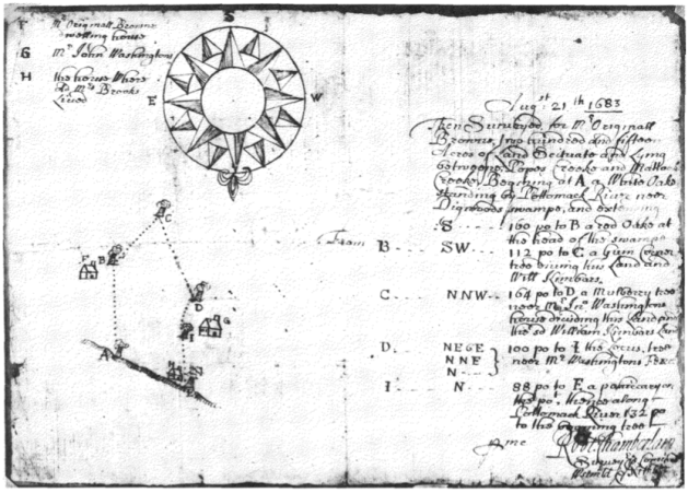
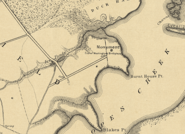
 The western border of the Washington land Lamkin surveyed was the road he called the Road to the Burnt House–it is the backwards L I have highlighted in this close up photo. The ultimate destination and name of that road is a question in and of itself, but for now, let’s focus on the spur that breaks off to its south–also highlighted here. Lamkin called this eastbound spur the Road to Washington’s Mill. Indeed, there was a mill at the head of Pope’s Creek for ages–the remains of its 20c iteration are still there to be seen. The area is now called Potomac Mills–not be confused with the giant mall on I-95 near DC. Right where Lamkin has written “Washington’s” there is another road forking with a spur headed back westward–making for a sort of backwards Z of a road.


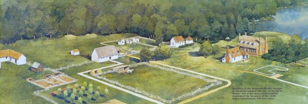 This NPS commissioned painting is a fine representation of the fanciful landscape as imagined by the 1920s folks, here painted with newer understandings of outbuildings layered onto it. It is not a bad vision of an 18c Virginia plantation–it’s just that it is composed of made up parts. No such plantation existed here. The painting shows the fanciful 1920s Memorial House Museum as the Washington home. It was not. In fact, there was very little actual research that went into its building. It was a vanity project by an autonomous group of commemorators and the home looks like a cross between Gunston Hall and Twifford which was the home of the main backer’s grandmother.
 first met. Those who know, inform us that the human species’ ability to manipulate its environment to suit its specific needs is the principal evolutionary advantage these animals have had over others. This has meant that human history has been filled with the making and remaking and remaking yet again of the places humans have called home. This endless game of revision and modification has left the world littered with remnants—each change large or small displaces something that was there first. In some areas, the change can be dramatic—say for example a farm field transformed into a subdivision. Other times though change can be as light as simple reordering, a shifting around of elements, a layering of one way of using a space atop another. Uses, ornaments, components, can be swallowed up by remaking, renovation, and host of other intentional changes. But there is a separate class of artifacts that just stay where there are unchanged, un-reused, and overlooked. These bits are not in the way enough to cause trouble to how things are being reordered, nor do they need to change to be part of something new. They no longer matter—and at the same time, they are in no one’s way so they illicit no fuss or concern to remove or change them. These objects are Remnantology.
 Principle Two: Remnantology is Material.
 Principle Six: Abandonment is not Remnantology.


 As NPS historian John Hennessy points out, there is not much else to lock in the story of the block. The local memory though is pretty strong, and needs to be given due weight—indeed, it has. There is a rival story that the block was a stepping stone for carriages and horses, but we can just push that aside since there is nothing about that role that would prevent the block from serving as an auction block as well at another time.


Recent Comments