In the summer of 1862 President Lincoln visited the city of Fredericksburg.  Soldiers of the United States had recently captured this hub of rail, road, and river virtually without incident and the President was in town to meet with his theatre commanders and to see the prize. Halfway between Washington and the Confederate capital of Richmond, Fredericksburg’s capture was one of the last moments when rational people could imagine that the war would be short and relatively painless.
Lincoln held meetings and visited local sites—including George Washington’s childhood home. In town, he met with General Marsena Patrick in the two-story neo-classically inflected Federal style Farmers’ Bank. The bank sat on the corner of Princess Anne and George Streets right across from St George’s Episcopal Church on its front and the town’s Presbyterian Church on its eastern side.

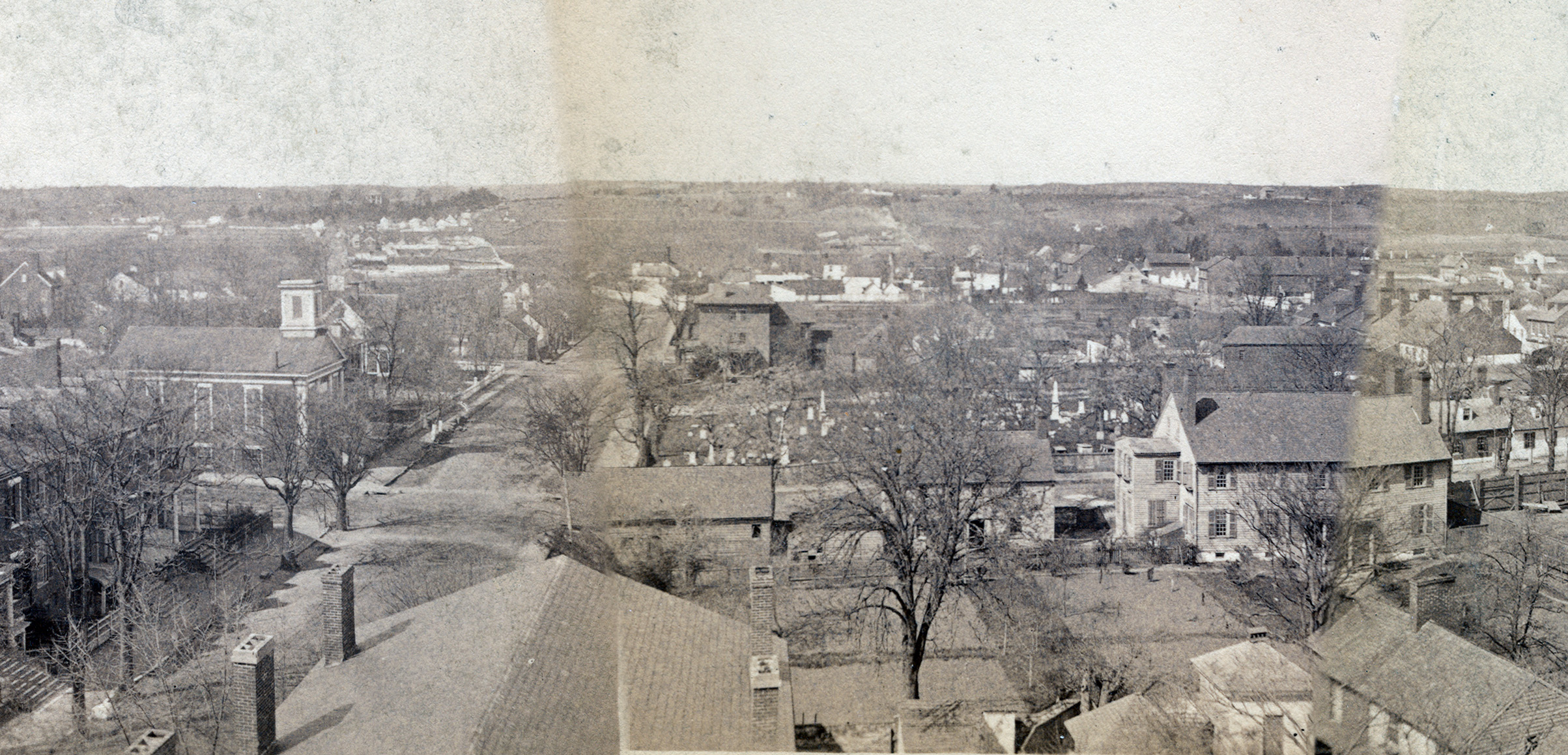
This section of the much-discussed 1888 St George Church panorama of Fredericksburg shows the roof and chimneys of the Farmers’ Bank on the left foreground. Note the use of the lots that are now mostly tarmac deserts. This section of the panorama came from Fredericksburg Remembered. http://cdn.loc.gov/service/pnp/cph/3c00000/3c00000/3c00600/3c00623v.jpg
Though lacking the adornments of ecclesiastical architecture, the Farmers’ Bank’s facade, style, and placement was nevertheless itself a statement of faith, solidity, and the American way. General Patrick’s selection of the bank as his own office—and a nerve center of the city’s occupation—enlisted the existing architecture of trust, power, and commerce for the for the cause of the Union.
The Farmers’ Bank has survived to today.
It has been a bank and office suites most of this time and is now one of Fredericksburg’s best historical buildings. Indeed, Fredericksburg NPS Battlefield Park Historian John Hennessy recently highlighted this fact for his blog readers reminding all that the bank is the only existing building we are certain Lincoln entered, walking over the bank’s worn Aquia sandstone steps and entering through the elaborate alcove entrance. The bank’s northeastern corner is especially notable for the large amount of Civil War graffiti resulting from bored soldiers carving their names and regiments into the brick (Other Civil War graffiti). In the 1930s, Historic American Building Survey architects studied the bank (then called the National Bank) and added it the list of the town’s charms. A 1990s drive through window and cash machine addition south of the bank are the only externally visible changes to the building which otherwise has maintained its historical feel capped off by a wooden Civil War era style sign.
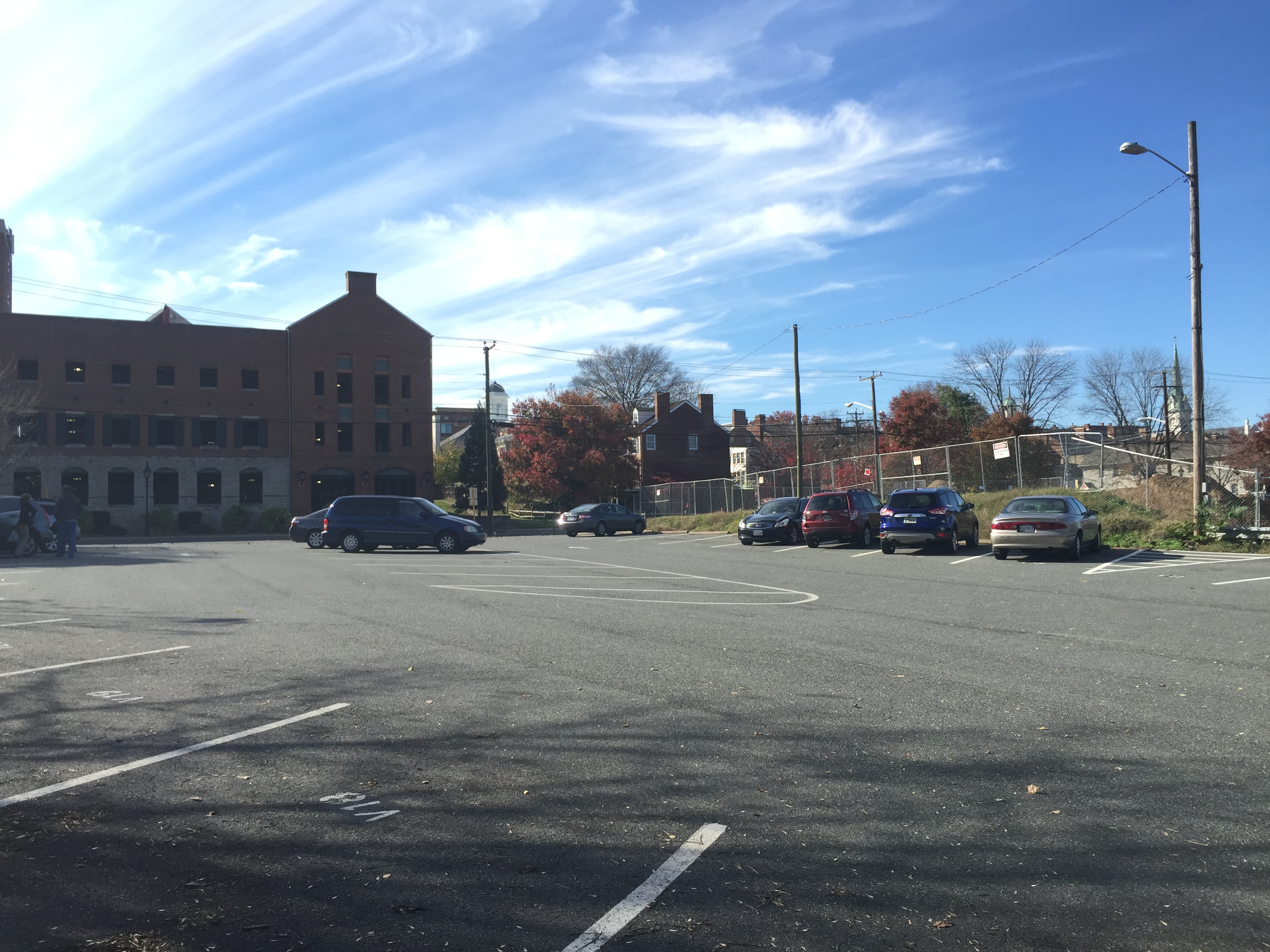
But changes in the larger lot have left the Farmers’ Bank an isolated historical Island in a tarmac desert. Beginning at least as early as the 1950s, Fredericksburgers transformed open in-town spaces into parking lots.

Seen in order on the right, the 1990s drive through bank addition, the south wall of the Farmers’ Bank, and the steeple of St George Episcopal Church.
In the nineteenth century, open lots were needed as work yards, kitchen gardens, and animal residences. But in the automobile era—and particularly after the 1960s when I-95 passed just west of town—the storage of temporarily dis-used cars became a primary concern. Property owners paved open lots and, as older buildings came down, their empty lots also joined the ranks of parking lots often in the shadow of roughly constructed side walls of remaining buildings meant to be seen only from the front. The result of this was to leave town feeling cold and gap toothed and filled with unplanned areas of undesirable, mostly unused, open spaces.

A Tarmac Desert on Sophia Street.
Once a lot is paved, the city or the owner are now committed to a never-ending maintenance regime as cracks have to be filled and holes patched. Paved lots also force collected rainwater to funnel into streets thus stressing removal systems, increasing flooding, and accelerating the erosion of older cobbles. The answer to this is of course more paving, so that over time, more and more of the cityscape became a tarmac desert. Whereas earthen lots absorb rainwater and produce greenery even when left alone and require no maintenance other than occasional mowing (or goat keeping), tarmac deserts produce nothing other than that distinctive smell in the heat and make corners for the collection of wind-borne trash. On top of that, the in and out flow of cars provide visible markers of when people are in a building and when they are not. The absence of cars signals a building’s emptiness to burglars while a dark lake of tar is itself an inviting terrain for all sorts of mischief. Nothing feels emptier than an vacant parking lot—and in Fredericksburg, most parking lots are empty most of the time and, being paved, can do nothing other than wait for the next car to park there. Paving a cityscape makes it an uninviting alienating tarmac desert that seems dark and dangerous most of the time.
The Farmers’ Bank sits now at the corner of just such an in-town desert. That makes the bank feel isolated and even irrelevant. This is just one of many ways whereby reliance on automobiles and that dependency has remade the landscape in ways that challenge preservation and a place’s historical feel.

The west wall of the Farmers’ Bank with the drive through on the right. Note the sale sign.
But now the bank faces a new threat—one worse perhaps than the shells and pocket knives it endured during the Civil War. When the economy bottomed out in 2008 most of Fredericksburg’s development project ground to a halt New condos near the rail tracks which once boasted signs claiming “Starting at $400,000!” soon boasted starting prices of $150,000 before being cut up into apartments. Subdivisions simply stopped with streets half fleshed out and stripped fields were left alone to regrow what grasses they could. Businesses failed and storefronts replaced displays with For Rent signs and papered-over windows. But all of that is over, and the development economy is once again booming. In a very short period of time the city saw a massive new courthouse constructed, a new downtown hotel right across the street, and many new homes fitting in between older ones. In just this last year new in-town projects have piled high-end housing into town and added eateries and even a glittering south-western styled brew pub.

Postmodern newly built townhouse filling in open spaces on the left and the stunningly out of place brew pub sitting on the corner of William and Winchester streets.
The good news (perhaps) is that much of this new development is taking place in lots that were previously tarred over. That addresses some of the aesthetical problems posed by tarmac deserts, but none of the environmental or historical preservation ones. The bad news is that all of this is happening so quickly that thorough archaeological is very challenging—and it seems in many cases that significant finds would not be enough to slow down the pace of building or even redirect it. Speed also leaves preservation–of buildings as well as less tangible but nevertheless important things like view sheds and historical feel– left in the dust and crushed by the bulldozer’s treads. Right now the future of the Farmers’ Bank is in question. A developer had bought the lot and received initial approval to fill the desert with condos. But the plan bogged down in levels of city government and all is on hold for now.

New construction on William Street right next to 19th century rows
At this year’s Council for North Eastern Historical Archeology conference in Fredericksburg, there was discussion about how the city, still lacking a protective archaeological ordinance, may be turning a blind eye to the destruction of the town’s material patrimony–a patrimony daily stewarded by Fredericksburg, but in reality owned by the nation. Again, the good news is that the city is on the way to hiring a preservation specialist to monitor work. Again, the bad news is that no one knows just how influential that person will be once hired and how much we may lose in the meantime.
Meanwhile though, decades’ old bad car-driven choices are still felt in a town walking the line between protecting its past and building for its future.
 The western border of the Washington land Lamkin surveyed was the road he called the Road to the Burnt House–it is the backwards L I have highlighted in this close up photo. The ultimate destination and name of that road is a question in and of itself, but for now, let’s focus on the spur that breaks off to its south–also highlighted here. Lamkin called this eastbound spur the Road to Washington’s Mill. Indeed, there was a mill at the head of Pope’s Creek for ages–the remains of its 20c iteration are still there to be seen. The area is now called Potomac Mills–not be confused with the giant mall on I-95 near DC. Right where Lamkin has written “Washington’s” there is another road forking with a spur headed back westward–making for a sort of backwards Z of a road.


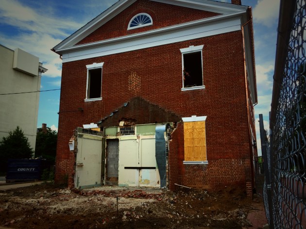 It seems though that the order was almost literally a day late and a dollar short. Last year, developer Mike Adams purchased the property from PNC Financial Services and floated a few plans for the building and lot. The latest is to turn the bank building into a restaurant and offices and put seven town houses in the lot. The former seems like a reasonable low-impact use of a historical structure, the later through still threatens to overwhelm the lot and over shadow the old building. The project began with the removal of the drive-through, but at the last moment the city’s Architectural Review Board–frequently a site of preservation battles–has thrown cold water on Adams’s plans. He has replied with a suit, and the city returned fire on Monday by sending over the cops to enforce the ban. From what I saw though, there was not much left to cry over.
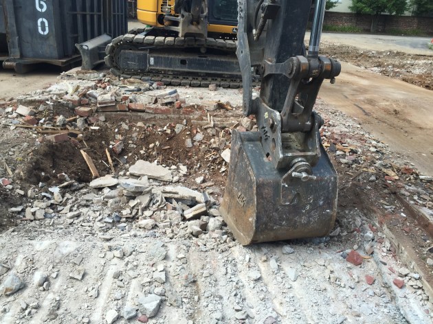


Recent Comments