Remnantology

Dedicated to the examination of the remnants. Phil Levy's words in reference to history, archaeology, Judaism, academe, music, outdoorsing…

Monthly Archives: February 2019

Surveys and Plats at George Washington’s Birthplace.

Here’s how this worked. A surveyor and his assistants would walk or ride the “metes and bounds” of a property noting the distinguishing landscape features that defined the various corners and limits of a property. Sometimes the border was a creek. Samuel Lamkin’s 1813 survey of the old Washington lands at GeWa for example, began his survey at Bridges Creek and then followed the run of “the said creek the several meanders thereof.” Other times it was a road or fence. A survey would often include notable landmarks like the “red oak at Pea Hill Gate” Lamkin singled out because any local would know just what he meant. Other times a party might make their own marks when nothing obvious was in sight.

Screen Shot 2019-02-26 at 4.12.28 PM

The opening lines of Samuel Lamkin’s 1813 survey as reprinted in 1859.

Three Chopt Road west of Richmond, Va for example is named for just such a surveyor’s mark. Not all markers survived though. Seventeenth-century surveys of the area that became Williamsburg, Va often referred to a now-long-lost large stone. No has ever located that exact spot adding a fun element of guess work to understanding property lines.

The game then was for the survey team to measure the direction and distance between each point as the team came upon them. So a survey was more in the form of what used to be called a “rudder,” — a verbal and numerical description of a walk over the land. Again from Lamkin: “Thence S 42 ½ [degrees] W 16 poles to Wakefield Gate at H.”

The next step was to “plat” the survey–to draw it as a map: to change the words to a form of art. Not all surveys were platted, but plats are among my very most favorite forms of documents around. The best have the survey written on them as well so you can sort of trace out the path yourself. These documents are full of detailed landscape information while giving us the opportunity to see the land as it was understood and prioritized in the past.

We are lucky that the Washington land had several surveys and plats over the years. These are vital tools in reconsidering the place and making it all make sense.

One of the earliest is the Robert Chamberlain’s 1683 map of the land that shows the location of John Washington’s (1631-1677) house on the right in relation to the Potomac River at the bottom of the map. The play is a masterpiece of the art form. From the compass sign to the little symbolic houses (stay tuned for a post about those), this is master craftsmanship here.

Screen Shot 2019-02-26 at 4.37.16 PM

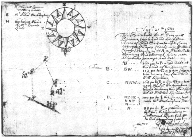
Robert Chamberlain, 1683

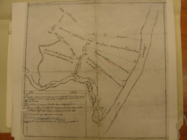
Not all plats are as clear as this one though. The Library of Congress has an obscure collection of Washington related documents that bear on the GeWa story. Take a look at this crazy plat and see if you can understand it. It represents a subdivison of what should be Washington and neighboring land from sometime in the early 18c. The waterway on the right is the Potomac. Note how the drafter has used hash marks to indicate shore lines. He has made the river rather narrow and shows the Maryland shore on the far right. But look at how those hash marks work along Pope’s Creek on the bottom of the map. See the problem? I guess this is the first survey plat By M. C. Esher.

HWC LOC DSC07389

Samuel Lamkin’s 1813 plat and survey is one of the most useful documents for trying to figure out some site mysteries. This is one we will return to again and again as I blog this project.
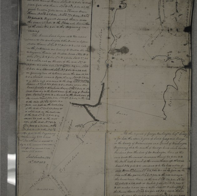
Photostat of survey plat Lamkin 1813 COLOR

Samuel Lamkin, 1813

George Washington’s Birthplace on C-SPAN.

George Washington’s Birthplace Map and Art.

We need some background. George Washington’s birthplace is in Westmoreland County, Virginia. It is just off of Route 3 about 40 miles east of Fredericksburg. If you drive out to visit there you can also swing by Stratford Hall a few miles farther east and see one of the most remarkable eighteenth-century Virginia homes. Washington’s Birthplace–some times called Pope’s Creek, other times called by its mid-18c name Wakefield–is owned and run by the National Park Service. The site’s NPS name is GeWa (first two letters of a site’s first two names), and I have gotten pretty used to that name. But GeWa is not an easy site to interpret to visitors. There was not much left of the old Washington homestead above ground by the start of nineteenth century. The location of the home—the Washington birth home—that so many have wanted to find has been a mystery since then. Everything built that is visible today is new–and error riddled. For a deeper background on the colonial history of the site and how the park has reported it, take a look at this Cultural Landscape Inventory. It is a good survey of the land ownership history and some of the challenges. It also embeds some of the assumptions we are now challenging.

076birthplace

This is Benson Lossing’s etching of the stone Parke Custis left at the site. Lossing never saw the stone. 

In 1815 George Washington Parke Custis and friends placed a commemorative stone where they thought the home had been, but they relied on the memory of others to locate the site. Since then the focus has been on where that stone had been. Even in the 1920s as the nation was getting ready for the Washington birth bicentennial, debate still focused on a chain of memory used to locate the lost stone. Independent evidence—like archaeology—was made to fit with stories and privileged memories rather receive its just due as an authoritative and independent stream of information. The park is now working to correct the confused mix of stories that have held sway for decades, and I am glad to be helping.

Gewa painting
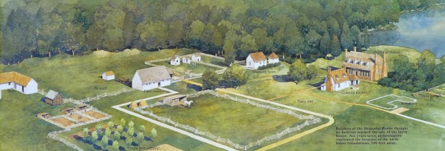
This NPS commissioned painting is a fine representation of the fanciful landscape as imagined by the 1920s folks, here painted with newer understandings of outbuildings layered onto it. It is not a bad vision of an 18c Virginia plantation–it’s just that it is composed of made up parts. No such plantation existed here. The painting shows the fanciful 1920s Memorial House Museum as the Washington home. It was not. In fact, there was very little actual research that went into its building. It was a vanity project by an autonomous group of commemorators and the home looks like a cross between Gunston Hall and Twifford which was the home of the main backer’s grandmother.

twiford-king-george-county-virginia-1024

This is a Historic American Building Survey photo of Twifford in King George County, Virginia. 

Not only that, but they sat their brick version of Twifford atop the remains of a curious outbuilding—remains which were destroyed in the building process. The rest of landscape is more imagination than anything else. We saw the same thing at Ferry Farm where an iconic set of errors were reinscribed with each new rendering giving new life over and over to old error. Nevertheless, this painting captures what visitors to the site see (more or less) and what rangers work so hard to clarify. It is a difficult task since so much of the available information and art is working against their efforts to share a better understanding. The little white outline on the right has been called Building X. That is the set of brick foundation features—excavated in 1930 and 1936 and which we re examined in 2013. These have been labeled the real Washington birth home, but that is a dubious claim at best. The whole site is a work in progress.

Screen Shot 2019-02-24 at 1.39.26 PM

Returning to the 1897 USGC map shows a bit more of this site from a similar angle. What the map labels as “Monument” is the site of the Memorial House Museum. That straight road that runs away from it now extends all the way down to Rt 3. When this map was drafted though, visitors arrived by steam boat on a Potomac dock at the end of the straight road running to the left past the Granary.

George Washington’s Birthplace Puzzles

I have been pretty obsessed with the landscape of George Washington’s birthplace of late. I first worked with the place’s records in 2008 or so when I was still putting together Ferry Farm’s story. As I wrote about therein, there was an adversarial relationship between the 1920s backers of the Birthplace project—the one that led to the creation of what the Park Service now calls “The Memorial House Museum,” and promoters for Ferry Farm. That conflict led me to the Park Service’s Birthplace archive to check out their files.

In 2013, I conducted a review of the site’s 1930s archaeology and with Ranger Amy Muraca and Alena Pirok, now of Georgia Southern, we showed that the current understanding of the site is not exactly supported by the archaeological record. Joy Beasley wrote an excellent short review of the place’s story and the battle between two buildings and their backers for the title of Washington’s birth home if you need a catch up. Our argument’s long and short though is that what is commonly called ‘Building X’ and considered the birth home is so contradiction ridden, that at best it makes a poor case for being that home. At worst it is all wrong and the home is elsewhere on the land.

The matter of the building cannot be settled without a re-excavation of the site. What I want to share here in blog form though is what I am seeing in the old maps of the landscape. I am trying to make sense of the old road system and the fragments we see of it in survey maps and other sources. Roads bear on the ages of buildings and all it speaks to how the landscape functioned in the eighteenth century. This is a puzzle—and like all puzzles, it is pretty absorbing. I have been at this for a while, so I am going to jump in where I am. There is no easy entry point, so any one is as good as any other.

But let’s begin with a clipping from the 1897 USGS survey map. That map built on an earlier one from the 1870s and incorporated a lot of collected information—some good, some bad. By this time, there were already commemorative efforts to mark Washington’s Birthplace, and that information is on the map. Much of it is wrong—but the drafters were not worried about that. What I like about this map though is that elements of the early 19c maps are still there and presumably still part of daily life for locals. The big straight roads you see are new ones built by the commemorators. The smaller crinklier ones are the old road system—the one now covered by trees and largely forgotten. That is the system I am trying to figure out.

Screen Shot 2017-01-25 at 2.34.44 PM

1897 USGS map of George Washington’s Birthplace in Westmoreland County, Virginia